PROJECT: DELISABATINI architetti
YEAR: 2018
NAME: New Urban Centre of Veliko Tarnovo - Master Plan, International Architecture Competition
LOCATION: VELIKO TARNOVO, BULGARIA
CLIENT: Municipality of Veliko Tarnovo
COLLABORATOR: Arch. Luca Lanciotti
DOWNLOAD:
PUBLICATIONS:
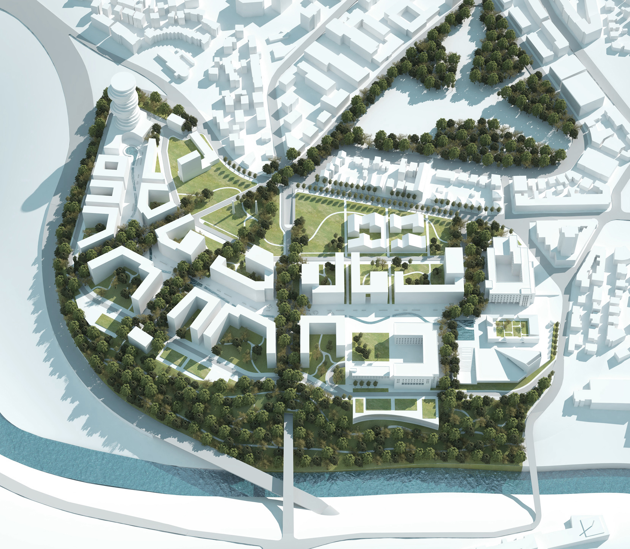
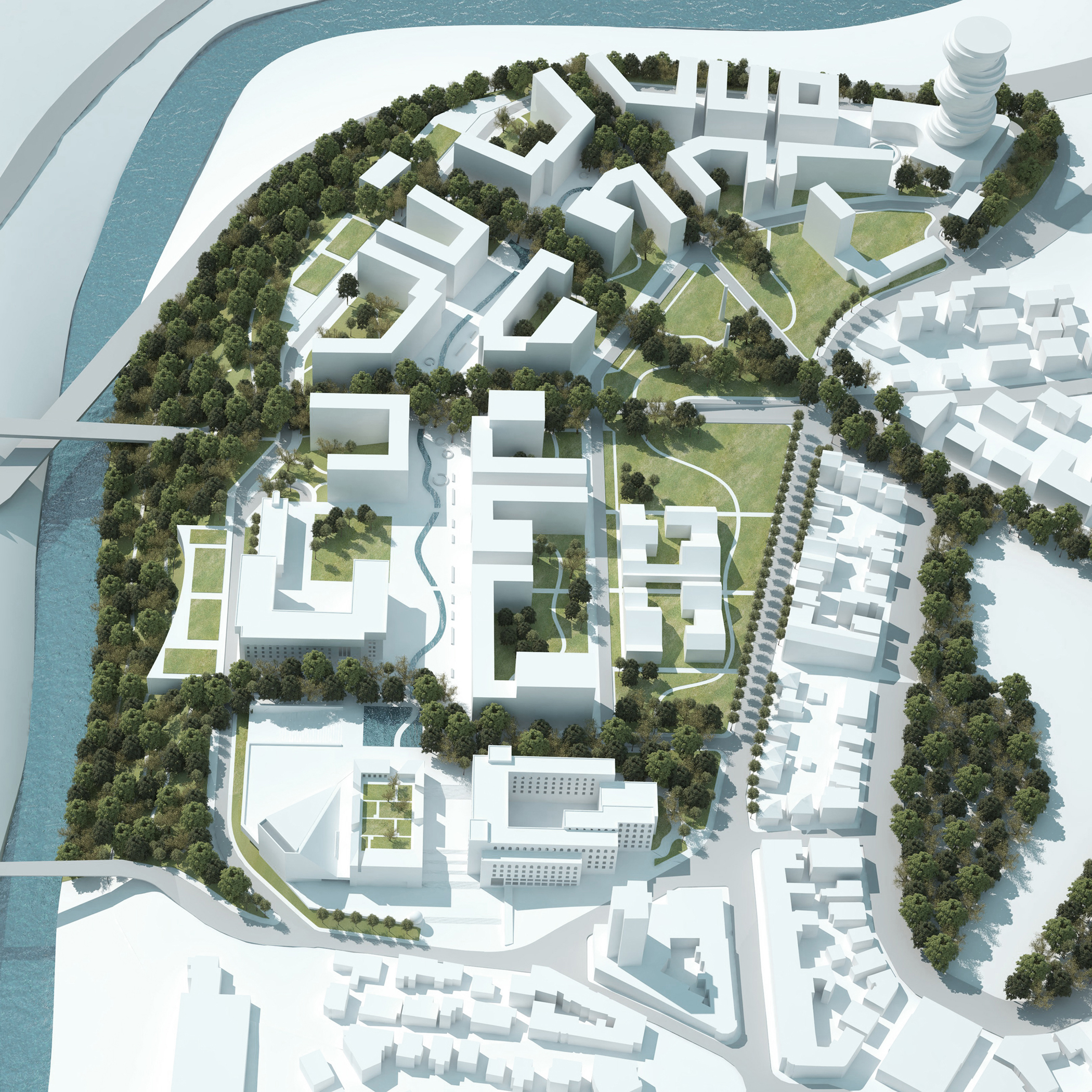
NUC project, valorising the high landscape quality and strategic position of the area in object, tries to change this peripheral area in a new central part of Veliko Tarnovo.
The aim of this program is to reconcile the creation of a “Green neighbourhood” and eco-friendly, and the demand of projecting many building (about 200000m2)
This new urban pole, as well as residences, has cultural and touristic facilities that will attract visitors from the city.
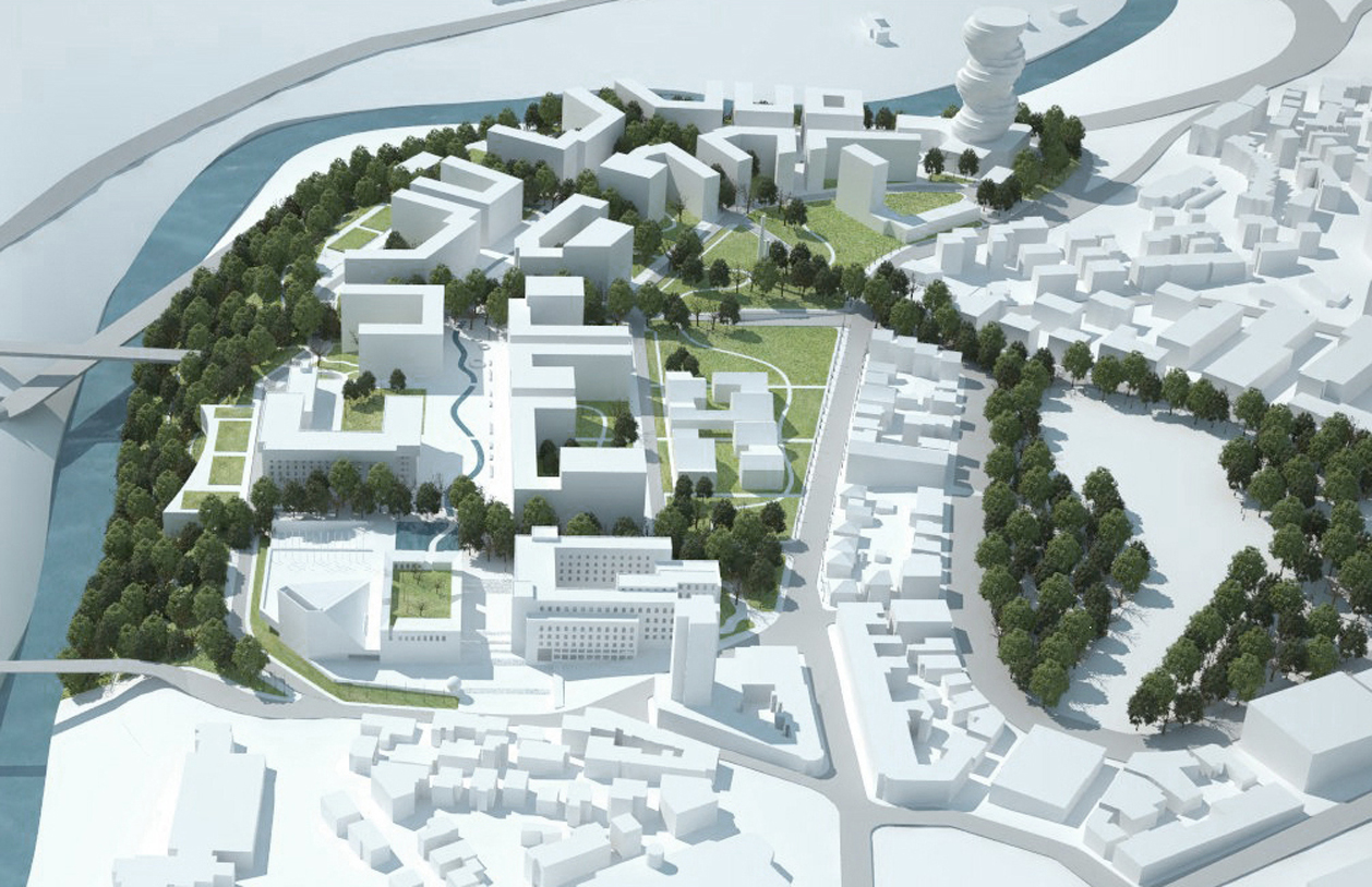
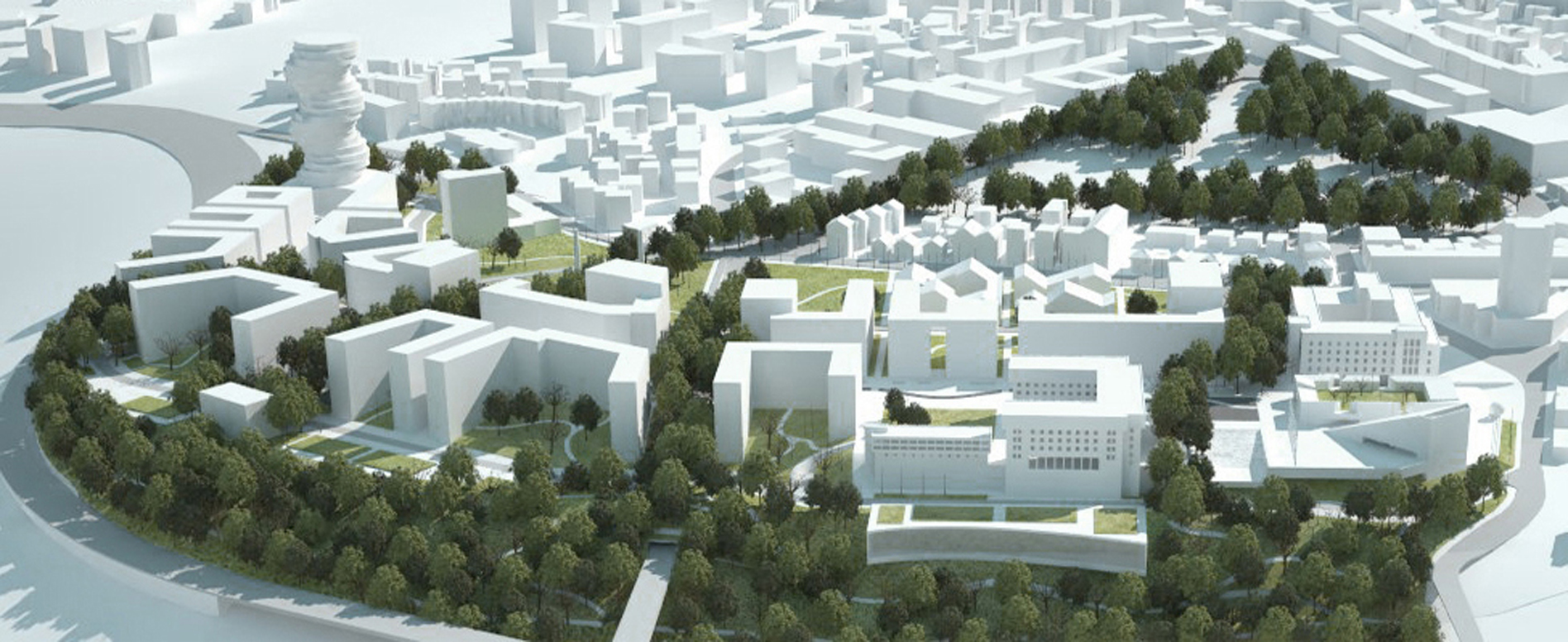
The project complements with the city urban framework; the NUC shape is recognizable, despite being an organic continuation of the city.
The new urban core has a strict physical and cultural links too with the historical and the modern central areas and establishes a strong dialogue with the river and the riverbank vegetation.
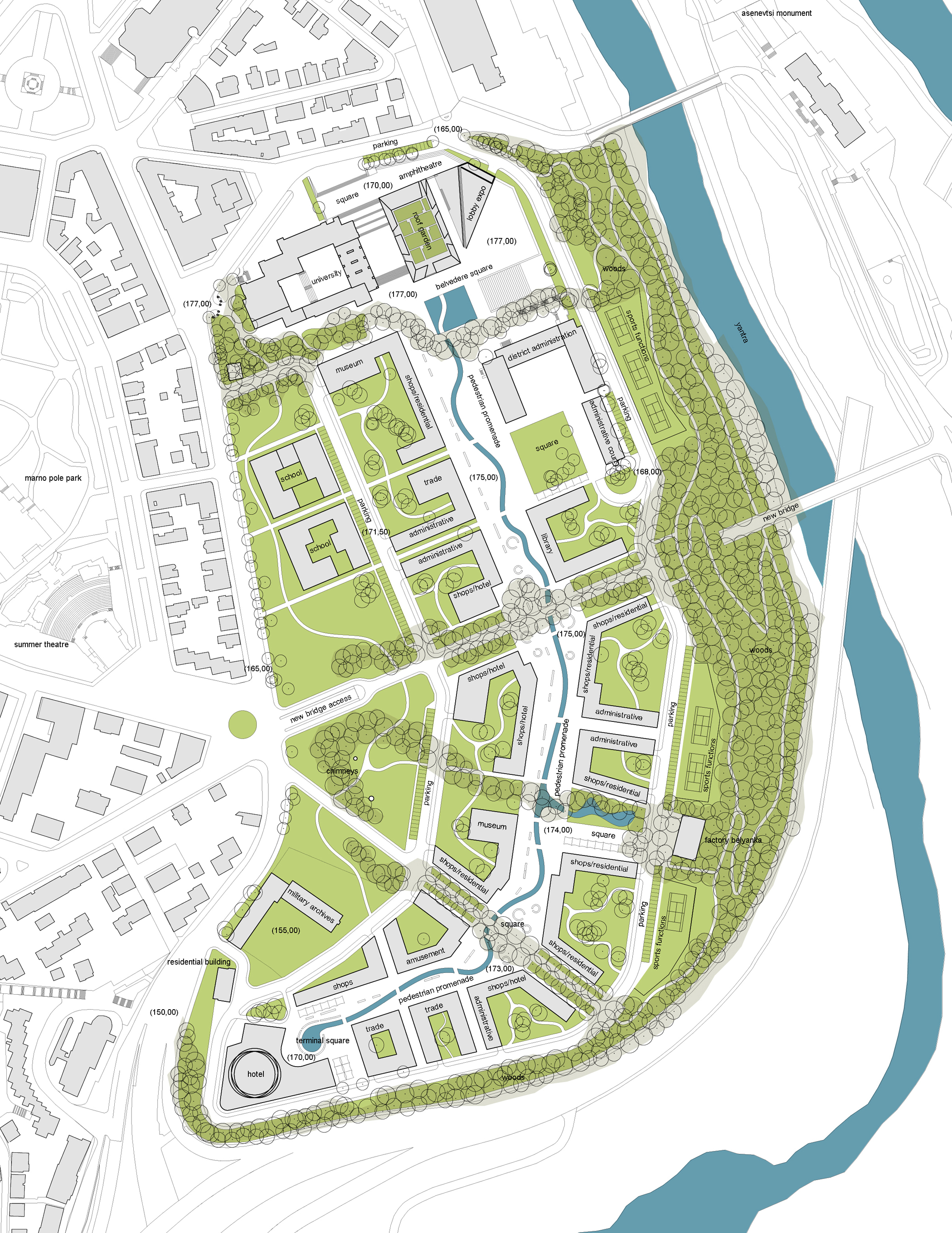
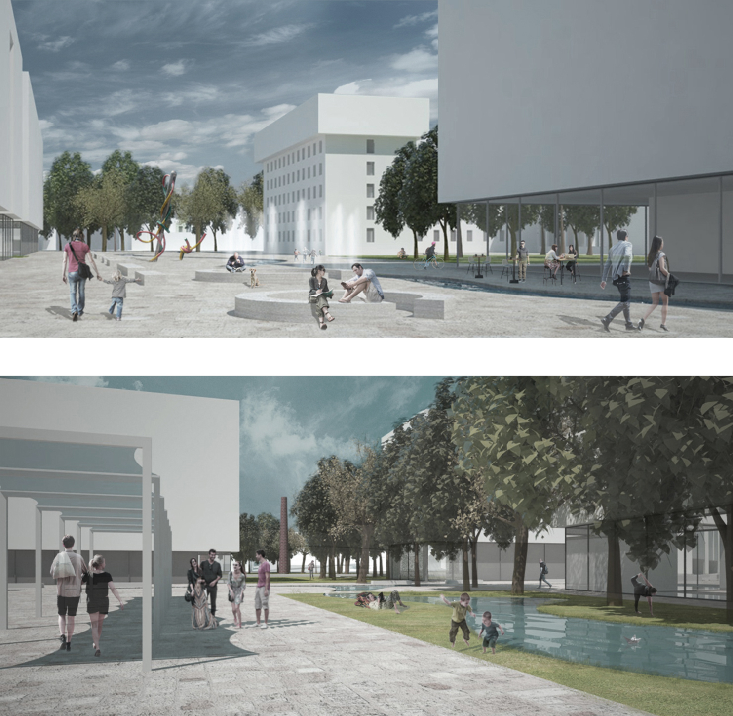
Administrative Court square qualifies the area between the existing building of the Administrative court and the new building of the Library. It is one of the spatial green breaks long the promenade.
This place visually connects the former Belyanka with the old chimneys. The square, stone paved, is enriched by a green garden, the water that, sinuous, flows into a large pool and by the wood that goes up from the riverbank until the two chimneys.
The project adapts to the shape of the ground, with a problematic topography, without upsetting, but using that as an asset (for example for the Expo building design).
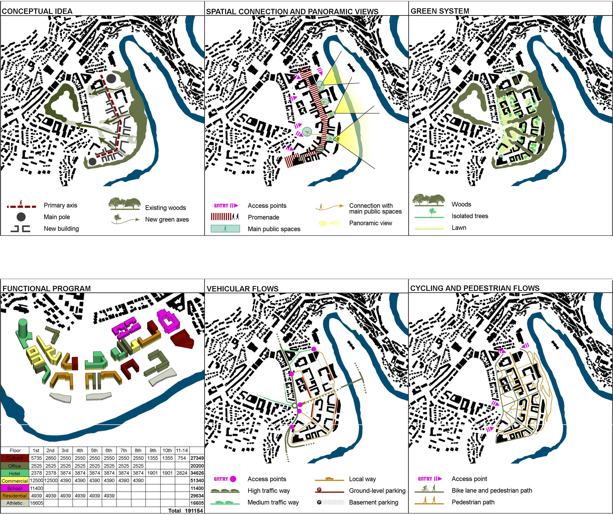
The spatial program of the new “Green neighbourhood” is based on the intersection and mutual contamination of two main signs.
The first one is an anthropic sign. A longitudinal axis that has two landmark buildings (the Tower hotel and the Expo) as pole. It is a designed paved promenade on which all new and existing buildings become its edges. The strategy of gathering the built along a longitudinal sign makes the possibility to use the surroundings zones for wide and comfortable green areas.
The second one is a natural sign. The wood of the riverbank expands, in opposite direction to the river, until it reaches Marno Pole Park. As “green tongues” (they are four), the trees go through new buildings and cross perpendicularly the main promenade. These “green theatrical wings” create spatial breaks at the promenade that becomes more comfortable and intimate.
Under and close to the trees there are special and equipped places, in which the user can play, relax and refresh itself.
Spatial connection and panoramic views: The central promenade has as purpose to create a comfortable, domestic and convenient place in this part of Veliko. This wide and designed pedestrian path, functionally and spatially connects all facilities (commercial, residential, touristic, and cultural, etc.) to ensure at NUC and Veliko Tarnovo a new attractive and calm place suitable for socializing. It is long about 500meters and wide about 22\30 meters.
The new buildings creates an urban frontage on the promenade. Behind it, they overlook on green courtyards, on the city and the river.
The preserved existing buildings (The Veliko Tarnovo University, the Veliko Tarnovo District Administration, the National Military History Archives, the former flour factory Belyanka, the residential building, etc.…) have been integrated with the new spatial organization.
In addition to the four “green tongues” the promenade, from to beginning to the end, has a lot of spatial breaks, like squares and open spaces, suitable for gathering of a large number of people attending various events.
An artificial thin river flows in the middle of the promenade paving long a sinuous path. It remembers the close river Yantra. It with stone benches, characterizes the public spaces that crosses.
Green system: In the program all existing trees in good condition will be preserved (at least relocated) and hundreds of new trees will be planted to complete the green design.
The ground level is mostly a green soil that is crossed by few vehicle roads and networks of bicycle and pedestrian paths.
The wood of the riverbank expands, in opposite direction to the river, until it reaches Marno Pole Park. As “green tongues” (they are four), the trees go through new buildings and cross perpendicularly the main promenade.
Functional program: The choice of multi-functional mix ensures the life of NUC during all the day. The pedestrian axis is always walked and uses by different types of users.
Commercial functions (shops, cafés, trade and amusement centres) fill the first and second levels of all the buildings with direct access from the promenade. Near the Tower hotel, there are some completely commercial buildings.
Schools are located next to the internal ring road toward the city for an immediate reachability also from the nearby neighbourhood.
Sports functions are located next to the internal ring road toward the river; they are linked to all paths up to the riverbank for the possibility to play water sports like rowing.
Vehicular flows: The purpose of the project is the reduction of traffic flows and the increase of pedestrian and bicycle flows.
The new traffic path is a ring that circles NUC, with only two crossing roads.
Linked to the existing traffic network in five points, this ring road carries people to the buildings backside, but also to the schools, hotels and sport buildings. Long this road, in strategic position, there are over-ground parking lots and the accesses for the many underground parking lots (in total about 75,000 m2, 2.050 PS). In this way, it is possible to have the maximum ground clear from vehicles and the maximum area for green land.
The connection with the city over the river has been maintained with a new bridge, but traffic does not cross NUC. It goes underground without creating any disturb at NUC residents and users.
The project saves some road layouts from PPA, for example the underground road that crosses NUC, and all the existing W&S networks. Inside NUC the vehicular flows have been reduced in favour of bicycle and pedestrian ones, ensuring a better and safer quality of life for residents and visitors too.
Cycling and pedestrian flows: In addition to the ring road, there are pedestrian and bicycle networks that totally cover the whole NUC up to Yantra riverbank.
These two networks are linked in many points at the pedestrian city network.